Gary Bacon’s June 2026 Report

Report on the Dig Tree Site
Dr Gary Bacon AM is a retired forester who seeks the company of old growth trees.
The Botanising Project
The Council of the Royal Historical Society of Queensland (RHSQ) approved in April 2025 a proposal that the Dig Tree Historical Reserve (the Reserve) be botanised pro bono and voucher specimens of in situ plants be collected and deposited within the Queensland Herbarium (QHerb), cognisant that no formal collection, in particular of the three carved icon coolibah trees, had previously been recorded.
Botanising of the Reserve was effected, 19-21 September 2025.
History Depot Camp 65
Depot Camp 65 on Cooper Creek was the launching pad for four members (Burke, Wills, King, Gray) of the Burke and Wills Expedition to set out on 16 December 1860 for the Gulf of Carpentaria. The depot party of four led by Brahe remained at the stockade until the morning of 21 April 1861 and then returned to the Darling River after burying supplies near the 'Dig' Tree with carved instructions. The survivors of the northern trek, Burke, Wills and King returned to the depot during the evening of 21 April, the very day that the depot party departed. Burke and Wills perished from starvation at the end of May 1861 further along Cooper Creek. King survived with the aid of the local Yandruwandha Aboriginal people.
The loss of seven men including the leaders, in the best funded expedition in Australian exploration, was in the view of later historians1, the direct result of the deadly and irretrievable- error of placing an incapable man in the responsible leader position 2. Nevertheless, the three blazed icon coolibahs, remain as a memorial to the first north-south continental crossing expedition and a symbol of the perseverance and hardships endured by the early explorers.
The Reserve
The remote Reserve is located in the far south-western Queensland’s Bulloo Shire, 71 km east of Innamincka (South Australia) and 326 km west of Thargomindah. It is sited on the northern bank of Cooper Creek at Bulla Bulla Crossing, six kilometres from the Nappa Merrie homestead.
The land containing the three carved coolibah trees is held under the trusteeship of the RHSQ and located within the 7275 square kilometre Nappa Merrie grazing property.
The Reserve was first gazetted in 19643 covering about one acre. Following a further survey in 1985 the site was gazetted in 19874 as R7 being lot 1 on plan CPR4 an area of 4470 square metres in the Parish Oontoo, County Cooper, on the bank of Cooper Creek. (Attachment 1).
The Burke and Wills Dig Tree was entered on the Queensland Heritage Register in 2003. The Reserve was entered 2016 on the Australian Heritage Database.
In 2020, the Dig Tree Visitor Experience Redesign Project refurbished the site with a path and boardwalk to protect the roots of the heritage-listed trees from foot traffic compaction. Interpretive signage was installed with replicas of the carved blazes. The project was funded by RHSQ, Bulloo Shire Council, the Commonwealth Government’s ‘Australian Heritage Grants Program’ and the Queensland Government’s Department of Environment and Science ‘Heritage Grants Program’, and Department of State Development ‘Building Our Regions Program’. In 2024 RHSQ
installed Wi-Fi to allow payment of the Conservation Fee ($20 per vehicle, $60 per bus, valid for six months) via a QR Code5.
Currently the Reserve is managed by the RHSQ with the active support of Nappa Merrie Station and the Bulloo Shire Council, with an on-site Ranger (Colin Mace).
Climate
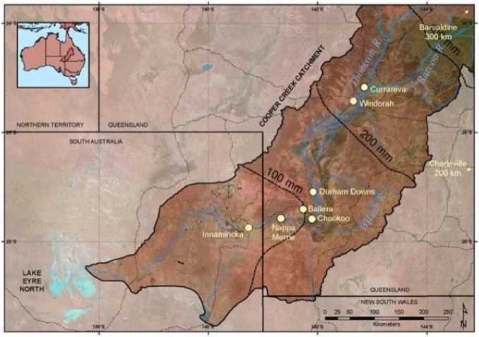
Cooper Creek, an ephemeral water source, was named by explorer Charles Sturt in 1845, during his expedition to locate an inland sea after Sir Charles Cooper, the then Chief Justice of South Australia. The local Yandruwandha people refer to it as Kooropari. It originates as the Barcoo and Thomson Rivers on the Great Divide in central Queensland and drains into Kati Thanda/Lake Eyre having a drainage area of 296 000 sq km (Attachment 2).
The Reserve on Nappa Merrie has a subtropical desert climate (Köppen: BWh)6 and experiences very hot, slightly wetter summers and mild, very dry winters 7. It lies within the 100mm annual isohyet.
The Trees
The iron-link fenced Reserve contains twelve trees of which ten are coolibahs (Eucalyptus coolabah) including the Dig Tree, Brahe’s Tree and Face Tree. Two adjacent to the Face tree are bean trees (Lysiphyllum gilvum).
Five significant trees (Attachments 3 & 4) were measured and material collected therefrom:
#1 Dig Tree — the tree now known as the Dig Tree, with three blazes (two grown over), Coordinates -27 37 26.2S, 141 14 32.79E, 76.3m AMSL;
#2 Brahé’s Tree — the tree identified by Dave Phoenix’s research8 as that originally blazed by Brahé (the ‘DIG’ blaze is now grown over);
#3 Face Tree — the tree carved by John Dick in 1898;
#4 & #5 – two Bean trees adjacent to #3.
Tree Taxonomy
Australian desert vegetation is a mosaic of plant communities made up of species with varying evolved tolerances to significant environmental stress (including exposure, drought, temperature, nutrition). The eucalypts are the quintessential native flora that have evolved to cover the diversity of environments over the whole continent9. The total number of eucalypts is debatable, usually quoted as over 900 distinct species. Taxonomists have had a veritable field day from the first naming of a Eucalypt by the French botanist Charles Louis L'Héritier de Brutelle in 1788. The name "Eucalyptus" comes from the Greek words eu (meaning "well") and kalyptos (meaning "covered"), referring to the operculum (a cap) that covers the flower buds.
There is no need here to cover the subsequent tortuous divisions of ‘eucalypts’ into three genera - Eucalyptus, Corymbia and Angophora and the latest addition, Blakella10. The coolibah tree has never left the Eucalyptus genus.
Nevertheless, the coolibah tree has itself been front and centre of taxonomic debate11ever since Baron Ferdinand von Mueller first described the species as Eucalyptus microtheca (ex Greek, ‘micro’ = small and ‘theke’ = container; referring to the small fruit of the species, amongst the smallest in the genus). He collected it as botanist in the Northern Territory on the 1855-56 Great Northern Expedition led by A C Gregory, who became the first Queensland Surveyor-General.
Unbeknown to Mueller at the time was that his classification comprising a single species across a very broad geographic distribution included a group of closely related taxa that subsequently were split into separate species and associated varieties and sub-species.
Gillan12 provides a fulsome detailed time journey through the maze of taxonomic development of Coolibah and serves to clarify why the nomenclature encountered in the literature can be so confusing. This taxonomic separation commenced in 1934 with the first comprehensive revision of the Eucalyptus by W F Blakely who recognised Eucalyptus coolabah (ex Wiradjuri word “gulabaa”). However, the binomial Eucalyptus microtheca continues to be broadly used13 even by the Queensland Heritage Register14 for the Dig Tree itself.
The vegetative material (bark, buds, flowers, capsules, crown foliage) collected in situ from the three carved coolibahs has been assessed and identified by QHerb as that used in current EUCLID15 naming, viz. Eucalyptus coolabah Blakely & Jacobs. Note that no varieties are recognised as is the case in adjacent South Australia16. The morphological differences to Eucalyptus microtheca F.Muell succinctly described by Booker and Kleinig17 as ‘E.coolabah is very similar to E.microtheca in most respects but has conspicuous, whitish smooth end- branches and more exerted valves of the fruit’, was a telling distinction in the field.
The Kew Herbarium type specimen for a Cooper Creek coolibah (E. coolabah Blakely & Jacobs) was collected from the Kopperamanna Mission, South Australia, distant hundreds of kilometers from the Reserve. A mounted in situ Dig Tree specimen is now held by Queensland Herbarium.
The Bean tree native to Cooper Creek has also received the attention of taxonomists over time. Currently Lysiphyllum gilvum (F.M.Bailey) Pedley APNI is the preferred name18 with Homotypic Synonyms Bauhinia cunninghamii f. gilva F.M.Bailey and Bauhinia gilva (F.M.Bailey) A.S.George.
Tree Measurements
Vegetative material was collected into plant presses from each of the five principal trees on the Reserve for identification and housing in the QHerb.
A number of measurements were recorded for each tree including Diameter (main trunk and at bifurcations), Height and Crown spread. These data were inserted into standard Tree Biomass and Carbon capture allometric equations with variables:
Density: 1150kg/m319, Quadratic Paraboloid form factor: 40%20, Decay 25%21 Carbon: 50% Dry wood22, Below Ground Biomass = 30% Above Ground Biomass23, CO2 sequestered (uptake) = 22/14 Carbon content (chemistry).
Tree age was determined using an average 0.15 cm (range 0.13 – 0.18) diameter annual increment recorded for coolibahs growing in similar riparian (mesic) environments across the border in South Australia24. This equates to a 0.16 cm mean diameter growth of woodlands (sans coolibahs) in low rainfall Queensland25. Estimates of diameter growth taken from non-destructive measurement of bark covering the 1898 carving on Face tree #3, ie the last 127 years, average 0.17 cm annual increment.
The results are tabled in Attachment 5. The largest coolibah tree, DIG #1, is estimated to contain an above ground Carbon content of 3.9 t and has sequestered 14.4 t of carbon dioxide over its 500+ years. In dendrochronological studies where radiocarbon dating has been used to determine the ages of veteran Australian trees 26including coolibahs27the commonly held view of the longevity of the species being around a maximum 350-450 years, has had to be significantly extended to a minimum 500 years. The Queensland Heritage Register28 and local Shire pamphlets state the age of the DIG tree between 200 to 250 years old, clearly an underestimate.
Tree Heath
All icon trees are in good health with vigorous expanding new leaf in the crowns. No ill effect of the full submergence of all the Reserve biota under the massive April 2025 floods was apparent. Some additional silt deposition was evident on the upper plateau surface and a little sheet erosion on the steep bank into Cooper Creek. One gall of Apiomorpha floralis of no concern was found on a fallen twig on the ground.
The Dig Tree was previously treated successfully for pests and diseases by a professional tree surgeon from the Queensland Department of Primary Industry and is in good condition. Cement had been inserted on one side of the base of the tree for stabilisation purposes. The inscriptions have been obscured over time by regrowth and the only clearly remaining blaze is LXV.
Other plants collected
The opportunity was taken to collect voucher specimens of regenerating ground cover growing on the Reserve and these have been processed and identified at QHerb (Attachment 6).
Three particular plants of botanical and historical interest were collected; whole plants including rhizomes of the desert fern Nardoo/Ngardu (Marsilea drummondi), pods of the native Bauhinia Bean Tree (Lysiphyllum gilvum) and stalks of the thicket shrub Lignum (Duma florulenta Synonym Muchlenbeckia cunninghamii). The original explorers ate nardoo and the beans of the native bauhinia.
Infrastructure
The record- breaking April 2025 flood at its peak is estimated to have covered the whole site including the Information Shelter on the rise above the Reserve proper by upwards of 10 metres.
Vehicle tracks and the car park area, formed walking tracks, boardwalks, railings, information boards and memorial cairns remained intact on the reserve.
Repairs to the Information Shelter and replacement of WiFi cabinet, solar panels unit and toilet block are planned via current proposals to State and Commonwealth flood disaster grants.
Footnotes
It is a pleasure to acknowledge the critical support of fellow travellers Carol Bacon, Caroline Fewtrell and Geoff Thompson and the insightful on-site assistance of Ranger Colin Mace.
References
1. Archibald Meston, Geographic history of Queensland, Dedicated to the Queensland PeopleBrisbane, Government Printer, 1895, pp. 197-199.
2. P. Saenger.P. (2012). ‘Trees associated with the Burke and Wills Expedition’, Chapter 16 in Australia’s Ever-changing Forests: Proceedings of the Eighth National Conference on Australian Forest History. Stubbs,B.J. et al. (ed.), 2012, ISBN 978-0-9757906-2-5, p. 2.
3. Queensland Government Gazette, 2 July 1964, p. 1083.
4. Queensland Government Gazette, 24 January 1987, p. 285. 5. Royal Historical Society Queensland, ‘Dig Tree’, accessed 19 July 2025, https://www.thedigtree.com.au/, https://www.thedigtree.com.au/dig-tree-reserve.
6. H.E. Beck, ‘High-resolution (1 km) Köppen-Geiger maps for 1901–2099 based on constrained CMIP6 projections’. J Scientific Data, 2023, accessed 20 July 2025, https://www.nature.com/articles/s41597-023-02549-6.
7. Bureau of Meteorology, ‘Climate statistics for Australian locations- Ballera Gas Field’, accessed 20 July 2025, https://www.bom.gov.au/climate/averages/tables/cw_045009.shtml.
8. D.G. Phoenix, (2017). ‘More like a picnic party: Burke and Wills: an analysis of the Victorian exploring expedition of 1860-1861’. PhD thesis, James Cook University, 2017,accessed 19 July 2025, https://researchonline.jcu.edu.au/50833/
9. R. Hill, et al, ‘Evolution of the eucalypts – an interpretation from the macrofossil record’. Australian Journal of Botany, vol. 64, 2016, p. 600-608.
10. M.D. Crisp, et al, ‘Perianth evolution and implications for generic delimitation in the eucalypts (Myrtaceae), including the description of the new genus, Blakella’. Journal of Systematics and Evolution, vol. 62, no. 5, 2024, p. 942-962.
11. J. Wrigley and M. Fagg, Eucalypts: A Celebration, Sydney, Allen & Unwin, 2012, pp. 352.
12. JS Gillen, Coolibah (Eucalyptus coolabah Blakely & Jacobs) of the Diamantina and Warburton River systems in north eastern South Australia. Report by Australian National University to the South Australian Arid Lands Natural Resources.2017, p. 10-14, accessed 22 July 2025, https://cdn.environment.sa.gov.au/landscape/docs/saal/2_coolibah_final_hmeditfinal_1.pdf
13. DJ Boland, et al, Forest Trees of Australia. CSIRO Publications, Melbourne, 1992, p. 494.
14. Queensland Heritage Register, ‘Burke and Wills Dig Tree’, accessed 22 July 2025, https://apps.des.qld.gov.au/heritage-register/detail/?id=601073.
15. EUCLID, (2020) Eucalypts of Australia Contributors: AV Slee, MIH Brooker, SM Duffy, JG West. Fourth Edition Centre for Australian National Biodiversity Research Canberra, 2020, accessed 22 July 2025, https://apps.lucidcentral.org/euclid/text/intro/about.htm. 16. South Australia Herbarium, ‘Eucalyptus coolabah’, accessed 25 May 2026, https://flora.sa.gov.au/taxon/27968-eucalyptus-coolabah.
17. I Brooker and D Kleinig, Eucalyptus An illustrated guide to identification. Reed New Holland. 2004, p. 155.
18. Kew Herbarium, ‘Lysiphyllum gilvum’, accessed 22 July 2025, https://powo.science.kew.org/taxon/urn:lsid:ipni.org:names:505338-1.
19. M Cause, et al, Queensland Timbers Their nomenclature, density and lyctid susceptibility. Qld Dept Forestry Tech Pam, no. 2, 1989, p. 33.
20. TV Oluwajuwon, et al, ‘Describing and Modelling Stem Form of Tropical Tree Species’. Forests, vol. 16, no. 1, 2025, p. 29.
21. SH Roxburgh, et al, (2006). ‘Assessing the carbon sequestration potential of managed forests: a case study from temperate Australia’. J. Applied Ecology, 43 (6). 2006, p. 1151.
22. J Rason, et al, ‘Spatial estimates of biomass in ‘mature’ native vegetation’. Australia National Carbon Accounting System, Technical Report No. 44. 2003, p. 56.
23. WH Burrows, et al, ‘Allometric relationships and community biomass estimates for some dominant eucalypts in Central Queensland woodlands’, Aust. J. Botany, 2000, vol. 48. p. 712.
24. JS Gillen, Coolibah (Eucalyptus coolabah Blakely & Jacobs) of the Diamantina and Warburton River systems in north eastern South Australia, 2017, p. 32.
25. MR Ngugi, et al, ‘Growth rates of Eucalyptus and other Australian native tree species derived from seven decades of growth monitoring’. J. Forest Research, vol. 26, no. 4, 2015, pp. 799–810.
26. SW Wood, et al, ‘Age and growth of a fire prone Tasmanian temperate old-growth forest stand dominated by Eucalyptus regnans, the world's tallest angiosperm’. Forest Ecology and Management, vol. 260, 2010, p. 438.J Turner,
‘Radiocarbon dating of wood and charcoal in an Australian forest ecosystem’. Aust. For. vol. 47, no. 2, 1984, p. 82. D Nicholson, ‘Rainforest tree ages’. Unpublished Qld Dept Forestry report, 1984, p. 6.
27. JS Gillen, Coolibah (Eucalyptus coolabah Blakely & Jacobs) of the Diamantina and Warburton River systems in north eastern South Australia, 2017, p. 33.
28. Queensland Heritage Register, ‘Burke and Wills Dig Tree’. accessed 2 June 2026, https://apps.des.qld.gov.au/heritage-register/detail/?id=601073.
Attachments
Attachment 1. Location of access path, board walks and interpretative signage installed 2019 on Dig Tree Historic Reserve.

Attachment 2: Cooper Creek catchment isohyets and location (Queensland Department of Regional Development, Manufacturing and Water (DRDMW) and The Pew Charitable Trusts). Note: Historical daily record of 169 mm recorded on 24 February 2026 at Nappa Marrie station.
Attachment 3. Healthy coolibahs, Tree #1 (DIG tree), Tree #2 (Brahé’s tree)
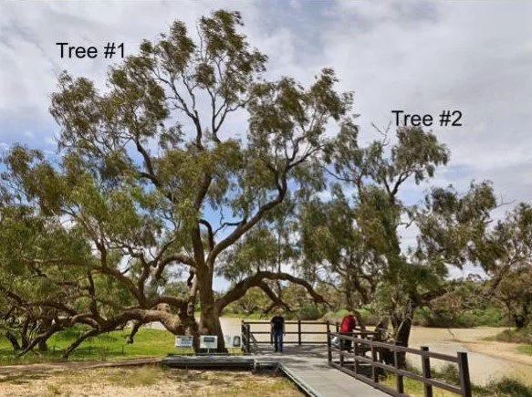
Fig 5: Tree Locations on Dig Tree Reserve, 2018
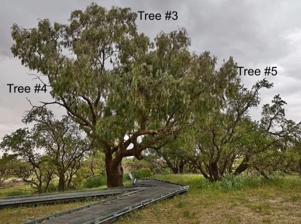
Fig 7: Tree measurements and calculated components of growth including Biomass, Carbon content, Tree Age, and Sequestered Carbon Dioxide
